ISSN 1672-1926
CN 62-1177/TE
RSS service
|
Email Alert
Toggle navigation
Home
About Journal
Journal Introduction
Editorial Board
Database Index
Awards
Journal Online
Current Issue
Latest Research Articles
Archive
Reading Ranking/a>
Download Ranking
Author Center
Solicitation Guidelines
Submission Guide
Writing Template
Article Self-check
Download Center
Ethics Statement
JNGGS
Contact Us
Chinese Version
Image/Table Caption
Advanced options
Journals
Article DOI
ALL
Natural Gas Geoscience
Publication Year From
Publication Year To
FromYear
1990
1991
1992
1993
1994
1995
1996
1997
1998
1999
2000
2001
2002
2003
2004
2005
2006
2007
2008
2009
2010
2011
2012
2013
2014
2015
2016
2017
2018
2019
2020
2021
2022
2023
2024
2025
ToYear
2025
2024
2023
2022
2021
2020
2019
2018
2017
2016
2015
2014
2013
2012
2011
2010
2009
2008
2007
2006
2005
2004
2003
2002
2001
2000
1999
1998
1997
1996
1995
1994
1993
1992
1991
1990
Volume
Issue
Author
Institution
Journals
Publication Years
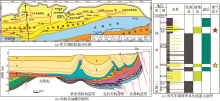
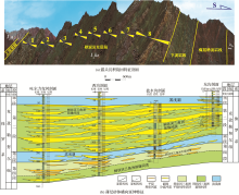
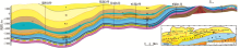
Fig.1
Geological characteristics of the Lower Jurassic in the middle east section of the northern tectonic belt of Kuqa Depression
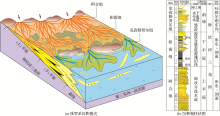
Fig.2
Sedimentary facies model of Middle and Lower Jurassic (Ahe-Yangxia-Kezilenur Formations)
Fig.3
Plan of sedimentary facies of Lower Jurassic Ahe Formation in the eastern part of Kuqa Depression in the northern tectonic belt of Kuqa Depression
Fig.4
Plan of sedimentary facies of Lower Jurassic Yangxia Formation in the eastern part of Kuqa Depression
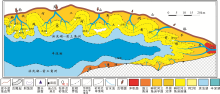
Fig.5
Plan of sedimentary facies of Middle Jurassic Kezilenur Formation in the eastern part of Kuqa Depression
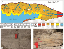
Fig.6
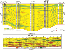
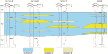
Sedimentary sand body and its configuration map of Lower Jurassic Ahe Formation in the middle section (Kuqa river area) of the northern tectonic belt of Kuqa Depression
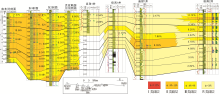
Fig.7
Sedimentary sand body correlation and configuration diagram in the middle and lower part of Jurassic Yangxia Formation in the middle eastern section of northern tectonic belt of Kuqa Depression
Fig.8
Characteristics of upper sand body of Jurassic Kezilenur Formation in Tugeerming area,northern tectonic belt of Kuqa Depression
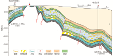
Fig.9
Jurassic hydrocarbon accumulation model in the east-west direction of Tugeerming anticline in the northern tectonic belt of Kuqa Depression
Fig.10
Jurassic accumulation model in the Dibei slope belt-Tugeerming uplift belt, middle-east section of northern tectonic belt of Kuqa Depression
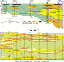
Fig.11
Reservoir correlation map of Jurassic Ahe Formation in the middle part (Kuqa river-Dibei slope belt) of northern tectonic belt of Kuqa Depression
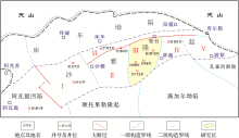
Fig.1
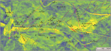
Tectonic zoning map in northern Tarim Basin
Table 1 Table of strata encountered of the Triassic, east of Tahe Oilfield
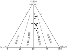
Fig.2
Triangular chart of rock classification of the fourth member of Akekule Formation, east of Tahe Oilfield
Fig.3
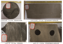
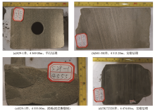
Lithologic characteristics of the fourth member of Akekule Formation, east of Tahe Oilfield
Fig.4
Sedimentary structure characteristics of the fourth member of Akekule Formation, east of Tahe Oilfield
Fig.5
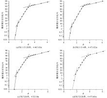
Granularity characteristics of the fourth member of Akekule Formation, east of Tahe Oilfield
Fig.6
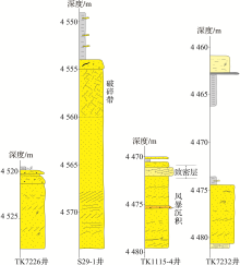
The phase sequence characteristics of the fourth member of Akekule Formation, east of Tahe Oilfield
Fig.7
The north-south well-tie sections in the fourth member of Akekule Formation, east of Tahe Oilfield
Fig.8
The attribute prediction map of the No.5 sublayer in the fourth member of Akekule Formation, east of Tahe Oilfield
page
Page 1 of 623
Total 12442 records
First page
Prev page
Next page
Last page


 甘公网安备 62010202000678号